Atmospheric, oceanic and land data handling
In this notebook we discuss the subtleties of how netCDF-SCM handles different data ‘realms’ and why these choices are made. The realms of interest are atmosphere, ocean and land and the distinction between the realms follows the CMIP6 realm controlled vocabulary.
[1]:
# NBVAL_IGNORE_OUTPUT
import traceback
from os.path import join

import iris
import iris.quickplot as qplt
import matplotlib.pyplot as plt
import numpy as np

from netcdf_scm.iris_cube_wrappers import CMIP6OutputCube
from netcdf_scm.utils import broadcast_onto_lat_lon_grid
[2]:
from pandas.plotting import register_matplotlib_converters

register_matplotlib_converters()
plt.style.use("bmh")
[3]:
import logging

logging.captureWarnings(True)

root_logger = logging.getLogger()
root_logger.setLevel(logging.WARNING)
fmt = logging.Formatter("{levelname}:{name}:{message}", style="{")
stream_handler = logging.StreamHandler()
stream_handler.setFormatter(fmt)
root_logger.addHandler(stream_handler)
[4]:
DATA_PATH_TEST = join("..", "..", "..", "tests", "test-data")
Note that all of our data is on a regular grid, we show an example of using native model grid data in the ocean section.
[5]:
tas_file = join(
    DATA_PATH_TEST,
    "cmip6output",
    "CMIP6",
    "CMIP",
    "IPSL",
    "IPSL-CM6A-LR",
    "historical",
    "r1i1p1f1",
    "Amon",
    "tas",
    "gr",
    "v20180803",
    "tas_Amon_IPSL-CM6A-LR_historical_r1i1p1f1_gr_191001-191003.nc",
)

gpp_file = tas_file.replace("Amon", "Lmon").replace("tas", "gpp")
csoilfast_file = gpp_file.replace("gpp", "cSoilFast")

hfds_file = join(
    DATA_PATH_TEST,
    "cmip6output",
    "CMIP6",
    "CMIP",
    "NOAA-GFDL",
    "GFDL-CM4",
    "piControl",
    "r1i1p1f1",
    "Omon",
    "hfds",
    "gr",
    "v20180701",
    "hfds_Omon_GFDL-CM4_piControl_r1i1p1f1_gr_015101-015103.nc",
)
Oceans
We start by loading our data.
[6]:
# NBVAL_IGNORE_OUTPUT
hfds = CMIP6OutputCube()
hfds.load_data_from_path(hfds_file)
netCDF-SCM will assume whether the data is “ocean”, “land” or “atmosphere”. The assumed realm can be checked by examining a ScmCube’s netcdf_scm_realm property.
In our case we have “ocean” data.
[7]:
hfds.netcdf_scm_realm
[7]:
'ocean'
If we have ocean data, then there is no data which will go in a “land” box. Hence, if we request e.g. World|Land data, we will get a warning and land data will not be returned.
[8]:
out = hfds.get_scm_timeseries(regions=["World", "World|Land"])
out["region"].unique()
WARNING:py.warnings:/Users/znicholls/Documents/AGCEC/netCDF-SCM/netcdf-scm/src/netcdf_scm/weights/__init__.py:869: UserWarning: Failed to create 'World|Land' weights: All weights are zero for region: `World|Land`
  warnings.warn(warn_str)

WARNING:netcdf_scm.iris_cube_wrappers:Not calculating land fractions as all required cubes are not available
WARNING:netcdf_scm.iris_cube_wrappers:Performing lazy conversion to datetime for calendar: 365_day. This may cause subtle errors in operations that depend on the length of time between dates
[8]:
array(['World'], dtype=object)
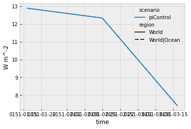
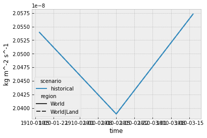
As there is no land data, the World mean is equal to the World|Ocean mean.
[9]:
# NBVAL_IGNORE_OUTPUT
hfds_scm_ts = hfds.get_scm_timeseries(regions=["World", "World|Ocean"])
hfds_scm_ts.line_plot(style="region")
np.testing.assert_allclose(
    hfds_scm_ts.filter(region="World").values,
    hfds_scm_ts.filter(region="World|Ocean").values,
);
WARNING:netcdf_scm.iris_cube_wrappers:Not calculating land fractions as all required cubes are not available
WARNING:netcdf_scm.iris_cube_wrappers:Performing lazy conversion to datetime for calendar: 365_day. This may cause subtle errors in operations that depend on the length of time between dates
When taking averages, there are 3 obvious options:
unweighted average
area weighted average
area and surface fraction weighted average
In netCDF-SCM, we provide the choice of the first two (if you want an unweighted average, please raise an issue on our issue tracker). Depending on the context, one will likely make more sense than the other. The user can specify this to ScmCube.get_scm_timeseries_weights via the cell_weights argument. If the user doesn’t supply a value, ScmCube will guess depending on what is most appropriate, see the docstring below for more
details.
[10]:
print(hfds.get_scm_timeseries_weights.__doc__)
        Get the scm timeseries weights

        Parameters
        ----------
        surface_fraction_cube : :obj:`ScmCube`, optional
            land surface fraction data which is used to determine whether a given
            gridbox is land or ocean. If ``None``, we try to load the land surface fraction automatically.

        areacell_scmcube : :obj:`ScmCube`, optional
            cell area data which is used to take the latitude-longitude mean of the
            cube's data. If ``None``, we try to load this data automatically and if
            that fails we fall back onto ``iris.analysis.cartography.area_weights``.

        regions : list[str]
            List of regions to use. If ``None`` then
            ``netcdf_scm.regions.DEFAULT_REGIONS`` is used.

        cell_weights : {'area-only', 'area-surface-fraction'}
            How cell weights should be calculated. If ``'area-surface-fraction'``, both cell area and its
            surface fraction will be used to weight the cell. If ``'area-only'``, only the cell's area
            will be used to weight the cell (cells which do not belong to the region are nonetheless
            excluded). If ``None``, netCDF-SCM will guess whether land surface fraction weights should
            be included or not based on the data being processed. When guessing, for ocean data,
            netCDF-SCM will weight cells only by the horizontal area of the cell i.e. no land fraction
            (see Section L5 of Griffies et al., *GMD*, 2016, `<https://doi.org/10.5194/gmd-9-3231-2016>`_).
            For land variables, netCDF-SCM will weight cells by both thier horizontal area and their land
            surface fraction. “Yes, you do need to weight the output by land frac (sftlf is the CMIP
            variable name).” (Chris Jones, *personal communication*, 18 April 2020). For land variables,
            note that there seems to be nothing in Jones et al., *GMD*, 2016
            (`<https://doi.org/10.5194/gmd-9-2853-2016>`_).

        log_failure : bool
            Should regions which fail be logged? If no, failures are raised as
            warnings.

        Returns
        -------
        dict of str: :obj:`np.ndarray`
            Dictionary of 'region name': weights, key: value pairs

        Notes
        -----
        Only regions which can be calculated are returned. If no regions can be calculated, an empty
        dictionary will be returned.
In the cells below, we show the difference the choice of cell weighting makes makes.
[11]:
def compare_weighting_options(input_scm_cube):
    unweighted_mean = input_scm_cube.cube.collapsed(
        ["latitude", "longitude"], iris.analysis.MEAN
    )

    area_cell = input_scm_cube.get_metadata_cube(
        input_scm_cube.areacell_var
    ).cube

    area_weights = broadcast_onto_lat_lon_grid(input_scm_cube, area_cell.data)
    area_weighted_mean = input_scm_cube.cube.collapsed(
        ["latitude", "longitude"], iris.analysis.MEAN, weights=area_weights
    )

    surface_frac = input_scm_cube.get_metadata_cube(
        input_scm_cube.surface_fraction_var
    ).cube

    area_sf = area_cell * surface_frac
    area_sf_weights = broadcast_onto_lat_lon_grid(input_scm_cube, area_sf.data)
    area_sf_weighted_mean = input_scm_cube.cube.collapsed(
        ["latitude", "longitude"], iris.analysis.MEAN, weights=area_sf_weights
    )

    plt.figure(figsize=(8, 4.5))
    qplt.plot(unweighted_mean, label="unweighted")
    qplt.plot(area_weighted_mean, label="area weighted")
    qplt.plot(
        area_sf_weighted_mean,
        label="area-surface fraction weighted",
        linestyle="--",
        dashes=(10, 10),
        linewidth=4,
    )

    plt.legend();
[12]:
# NBVAL_IGNORE_OUTPUT
compare_weighting_options(hfds)
WARNING:py.warnings:/Users/znicholls/miniconda3/envs/netcdf-scm/lib/python3.9/site-packages/iris/cube.py:3218: UserWarning: Collapsing spatial coordinate 'latitude' without weighting
  warnings.warn(msg.format(coord.name()))
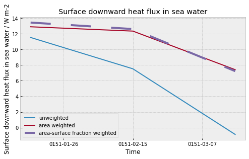
We go to the trouble of taking these area-surface fraction weightings because they matter. In particular, the area weight is required to not overweight the poles (on whatever grid we’re working) whilst the surface fraction allows the user to ensure that the cells’ contribution to an average reflects how much they belong in a given ‘SCM box’.
More detail
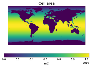
We can check which variable is being used for the cell areas by loooking at ScmCube.areacell_var. For ocean data this is areacello.
[13]:
hfds.areacell_var
[13]:
'areacello'
[14]:
hfds_area_cell = hfds.get_metadata_cube(hfds.areacell_var).cube
qplt.pcolormesh(hfds_area_cell);
We can check which variable is being used for the surface fraction by loooking at ScmCube.surface_fraction_var. For ocean data this is sftof.
[15]:
hfds.surface_fraction_var
[15]:
'sftof'
[16]:
hfds_surface_frac = hfds.get_metadata_cube(hfds.surface_fraction_var).cube
qplt.pcolormesh(hfds_surface_frac);
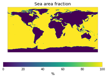
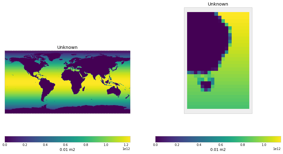
The product of the area of the cells and the surface fraction gives us the area-surface fraction weights. The addition of the surface fraction only really matters near the coastlines where cells are neither entirely land nor entirely ocean.
[17]:
hfds_area_sf = hfds_area_cell * hfds_surface_frac

plt.figure(figsize=(16, 9))
plt.subplot(121)
qplt.pcolormesh(hfds_area_sf,)

plt.subplot(122)
lat_con = iris.Constraint(latitude=lambda cell: -50 < cell < -20)
lon_con = iris.Constraint(longitude=lambda cell: 140 < cell < 160)
qplt.pcolormesh(hfds_area_sf.extract(lat_con & lon_con),);
For ocean data, by default netCDF-SCM will only use the area weights. If we turn the logging up, we can see the decisions being made internally (look at the line following the line containing cell_weights).
[18]:
# NBVAL_IGNORE_OUTPUT
root_logger.setLevel(logging.DEBUG)
# also load the cube again so the caching doesn't hide the logging messages
hfds = CMIP6OutputCube()
hfds.load_data_from_path(hfds_file)
DEBUG:netcdf_scm.iris_cube_wrappers:loading cube ../../../tests/test-data/cmip6output/CMIP6/CMIP/NOAA-GFDL/GFDL-CM4/piControl/r1i1p1f1/Omon/hfds/gr/v20180701/hfds_Omon_GFDL-CM4_piControl_r1i1p1f1_gr_015101-015103.nc
DEBUG:netcdf_scm.iris_cube_wrappers:loading cube ../../../tests/test-data/cmip6output/CMIP6/CMIP/NOAA-GFDL/GFDL-CM4/piControl/r1i1p1f1/Ofx/areacello/gr/v20180701/areacello_Ofx_GFDL-CM4_piControl_r1i1p1f1_gr.nc
[19]:
# NBVAL_IGNORE_OUTPUT
hfds_area_weights = broadcast_onto_lat_lon_grid(hfds, hfds_area_cell.data)
hfds_area_weighted_mean = hfds.cube.collapsed(
    ["latitude", "longitude"], iris.analysis.MEAN, weights=hfds_area_weights
)

netcdf_scm_calculated = hfds.get_scm_timeseries(regions=["World"]).timeseries()

np.testing.assert_allclose(
    hfds_area_weighted_mean.data,
    netcdf_scm_calculated.values.squeeze(),
    rtol=1e-6,
)

netcdf_scm_calculated.T
DEBUG:netcdf_scm.iris_cube_wrappers:cell_weights: None
DEBUG:netcdf_scm.iris_cube_wrappers:self.netcdf_scm_realm: ocean
DEBUG:netcdf_scm.iris_cube_wrappers:Using: <class 'netcdf_scm.weights.AreaWeightCalculator'>
DEBUG:netcdf_scm.iris_cube_wrappers:loading cube ../../../tests/test-data/cmip6output/CMIP6/CMIP/NOAA-GFDL/GFDL-CM4/piControl/r1i1p1f1/Ofx/sftof/gr/v20180701/sftof_Ofx_GFDL-CM4_piControl_r1i1p1f1_gr.nc
DEBUG:netcdf_scm.weights:sftof data max is 100.0, dividing by 100.0 to convert units to fraction
DEBUG:netcdf_scm.iris_cube_wrappers:Crunching SCM timeseries in memory
WARNING:netcdf_scm.iris_cube_wrappers:Not calculating land fractions as all required cubes are not available
WARNING:netcdf_scm.iris_cube_wrappers:Performing lazy conversion to datetime for calendar: 365_day. This may cause subtle errors in operations that depend on the length of time between dates
[19]:
| activity_id | CMIP |
|---|---|
| climate_model | GFDL-CM4 |
| member_id | r1i1p1f1 |
| mip_era | CMIP6 |
| model | unspecified |
| region | World |
| scenario | piControl |
| unit | W m^-2 |
| variable | hfds |
| variable_standard_name | surface_downward_heat_flux_in_sea_water |
| time | |
| 0151-01-16 12:00:00 | 12.899261 |
| 0151-02-15 00:00:00 | 12.346571 |
| 0151-03-16 12:00:00 | 7.410532 |
If we specify that surface fractions should be included, the timeseries calculated by netCDF-SCM is the same as the timeseries calculated using the surface fraction and area weights.
[20]:
# NBVAL_IGNORE_OUTPUT
hfds_area_sf_weights = broadcast_onto_lat_lon_grid(hfds, hfds_area_sf.data)
hfds_area_sf_weighted_mean = hfds.cube.collapsed(
    ["latitude", "longitude"], iris.analysis.MEAN, weights=hfds_area_sf_weights
)

netcdf_scm_calculated = hfds.get_scm_timeseries(
    regions=["World"], cell_weights="area-surface-fraction"
).timeseries()

np.testing.assert_allclose(
    hfds_area_sf_weighted_mean.data,
    netcdf_scm_calculated.values.squeeze(),
    rtol=1e-6,
)

netcdf_scm_calculated.T
DEBUG:netcdf_scm.iris_cube_wrappers:cell_weights: area-surface-fraction
DEBUG:netcdf_scm.iris_cube_wrappers:Using: <class 'netcdf_scm.weights.AreaSurfaceFractionWeightCalculator'>
DEBUG:netcdf_scm.weights:sftof data max is 100.0, dividing by 100.0 to convert units to fraction
DEBUG:netcdf_scm.iris_cube_wrappers:Crunching SCM timeseries in memory
WARNING:netcdf_scm.iris_cube_wrappers:Not calculating land fractions as all required cubes are not available
WARNING:netcdf_scm.iris_cube_wrappers:Performing lazy conversion to datetime for calendar: 365_day. This may cause subtle errors in operations that depend on the length of time between dates
[20]:
| activity_id | CMIP |
|---|---|
| climate_model | GFDL-CM4 |
| member_id | r1i1p1f1 |
| mip_era | CMIP6 |
| model | unspecified |
| region | World |
| scenario | piControl |
| unit | W m^-2 |
| variable | hfds |
| variable_standard_name | surface_downward_heat_flux_in_sea_water |
| time | |
| 0151-01-16 12:00:00 | 13.440214 |
| 0151-02-15 00:00:00 | 12.608150 |
| 0151-03-16 12:00:00 | 7.226662 |
[21]:
root_logger.setLevel(logging.WARNING)
Land
Next we look at land data.
[22]:
gpp = CMIP6OutputCube()
gpp.load_data_from_path(gpp_file)

csoilfast = CMIP6OutputCube()
csoilfast.load_data_from_path(csoilfast_file)
[23]:
gpp.netcdf_scm_realm
[23]:
'land'
[24]:
csoilfast.netcdf_scm_realm
[24]:
'land'
If we have land data, then there is no data which will go in a “ocean” box. Hence, if we request e.g. World|Ocean data, we will get a warning and ocean data will not be returned.
[25]:
out = gpp.get_scm_timeseries(regions=["World", "World|Ocean"])
out["region"].unique()
WARNING:py.warnings:/Users/znicholls/Documents/AGCEC/netCDF-SCM/netcdf-scm/src/netcdf_scm/weights/__init__.py:869: UserWarning: Failed to create 'World|Ocean' weights: All weights are zero for region: `World|Ocean`
  warnings.warn(warn_str)

WARNING:py.warnings:/Users/znicholls/miniconda3/envs/netcdf-scm/lib/python3.9/site-packages/iris/coords.py:1410: UserWarning: Collapsing a non-contiguous coordinate. Metadata may not be fully descriptive for 'latitude'.
  warnings.warn(msg.format(self.name()))

WARNING:py.warnings:/Users/znicholls/miniconda3/envs/netcdf-scm/lib/python3.9/site-packages/iris/coords.py:1410: UserWarning: Collapsing a non-contiguous coordinate. Metadata may not be fully descriptive for 'longitude'.
  warnings.warn(msg.format(self.name()))

WARNING:netcdf_scm.iris_cube_wrappers:Not calculating land fractions as all required cubes are not available
[25]:
array(['World'], dtype=object)
As there is no ocean data, the World mean is equal to the World|Land mean.
[26]:
# NBVAL_IGNORE_OUTPUT
gpp_scm_ts = gpp.get_scm_timeseries(regions=["World", "World|Land"])
gpp_scm_ts.line_plot(style="region")
np.testing.assert_allclose(
    gpp_scm_ts.filter(region="World").values,
    gpp_scm_ts.filter(region="World|Land").values,
);
WARNING:py.warnings:/Users/znicholls/miniconda3/envs/netcdf-scm/lib/python3.9/site-packages/iris/coords.py:1410: UserWarning: Collapsing a non-contiguous coordinate. Metadata may not be fully descriptive for 'latitude'.
  warnings.warn(msg.format(self.name()))

WARNING:py.warnings:/Users/znicholls/miniconda3/envs/netcdf-scm/lib/python3.9/site-packages/iris/coords.py:1410: UserWarning: Collapsing a non-contiguous coordinate. Metadata may not be fully descriptive for 'longitude'.
  warnings.warn(msg.format(self.name()))

WARNING:netcdf_scm.iris_cube_wrappers:Not calculating land fractions as all required cubes are not available
[27]:
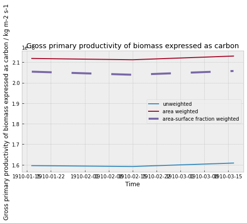
# NBVAL_IGNORE_OUTPUT
compare_weighting_options(gpp)
WARNING:py.warnings:/Users/znicholls/miniconda3/envs/netcdf-scm/lib/python3.9/site-packages/iris/cube.py:3218: UserWarning: Collapsing spatial coordinate 'latitude' without weighting
  warnings.warn(msg.format(coord.name()))

WARNING:py.warnings:/Users/znicholls/miniconda3/envs/netcdf-scm/lib/python3.9/site-packages/iris/coords.py:1410: UserWarning: Collapsing a non-contiguous coordinate. Metadata may not be fully descriptive for 'latitude'.
  warnings.warn(msg.format(self.name()))

WARNING:py.warnings:/Users/znicholls/miniconda3/envs/netcdf-scm/lib/python3.9/site-packages/iris/coords.py:1410: UserWarning: Collapsing a non-contiguous coordinate. Metadata may not be fully descriptive for 'longitude'.
  warnings.warn(msg.format(self.name()))
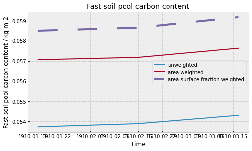
[28]:
# NBVAL_IGNORE_OUTPUT
compare_weighting_options(csoilfast)
WARNING:py.warnings:/Users/znicholls/miniconda3/envs/netcdf-scm/lib/python3.9/site-packages/iris/cube.py:3218: UserWarning: Collapsing spatial coordinate 'latitude' without weighting
  warnings.warn(msg.format(coord.name()))

WARNING:py.warnings:/Users/znicholls/miniconda3/envs/netcdf-scm/lib/python3.9/site-packages/iris/coords.py:1410: UserWarning: Collapsing a non-contiguous coordinate. Metadata may not be fully descriptive for 'latitude'.
  warnings.warn(msg.format(self.name()))

WARNING:py.warnings:/Users/znicholls/miniconda3/envs/netcdf-scm/lib/python3.9/site-packages/iris/coords.py:1410: UserWarning: Collapsing a non-contiguous coordinate. Metadata may not be fully descriptive for 'longitude'.
  warnings.warn(msg.format(self.name()))

WARNING:py.warnings:/Users/znicholls/miniconda3/envs/netcdf-scm/lib/python3.9/site-packages/iris/coords.py:1410: UserWarning: Collapsing a non-contiguous coordinate. Metadata may not be fully descriptive for 'latitude'.
  warnings.warn(msg.format(self.name()))

WARNING:py.warnings:/Users/znicholls/miniconda3/envs/netcdf-scm/lib/python3.9/site-packages/iris/coords.py:1410: UserWarning: Collapsing a non-contiguous coordinate. Metadata may not be fully descriptive for 'longitude'.
  warnings.warn(msg.format(self.name()))

WARNING:py.warnings:/Users/znicholls/miniconda3/envs/netcdf-scm/lib/python3.9/site-packages/iris/coords.py:1410: UserWarning: Collapsing a non-contiguous coordinate. Metadata may not be fully descriptive for 'latitude'.
  warnings.warn(msg.format(self.name()))

WARNING:py.warnings:/Users/znicholls/miniconda3/envs/netcdf-scm/lib/python3.9/site-packages/iris/coords.py:1410: UserWarning: Collapsing a non-contiguous coordinate. Metadata may not be fully descriptive for 'longitude'.
  warnings.warn(msg.format(self.name()))
For land data, by default netCDF-SCM will use the area and surface fraction weights. Once again, if we turn the logging up, we can see the decisions being made internally.
[29]:
# NBVAL_IGNORE_OUTPUT
root_logger.setLevel(logging.DEBUG)
csoilfast = CMIP6OutputCube()
csoilfast.load_data_from_path(csoilfast_file)
DEBUG:netcdf_scm.iris_cube_wrappers:loading cube ../../../tests/test-data/cmip6output/CMIP6/CMIP/IPSL/IPSL-CM6A-LR/historical/r1i1p1f1/Lmon/cSoilFast/gr/v20180803/cSoilFast_Lmon_IPSL-CM6A-LR_historical_r1i1p1f1_gr_191001-191003.nc
DEBUG:netcdf_scm.iris_cube_wrappers:loading cube ../../../tests/test-data/cmip6output/CMIP6/CMIP/IPSL/IPSL-CM6A-LR/historical/r1i1p1f1/fx/areacella/gr/v20180803/areacella_fx_IPSL-CM6A-LR_historical_r1i1p1f1_gr.nc
[30]:
# NBVAL_IGNORE_OUTPUT
netcdf_scm_calculated = csoilfast.get_scm_timeseries(
    regions=["World"]
).timeseries()

netcdf_scm_calculated.T
DEBUG:netcdf_scm.iris_cube_wrappers:cell_weights: None
DEBUG:netcdf_scm.iris_cube_wrappers:self.netcdf_scm_realm: land
DEBUG:netcdf_scm.iris_cube_wrappers:Using: <class 'netcdf_scm.weights.AreaSurfaceFractionWeightCalculator'>
DEBUG:netcdf_scm.iris_cube_wrappers:loading cube ../../../tests/test-data/cmip6output/CMIP6/CMIP/IPSL/IPSL-CM6A-LR/historical/r1i1p1f1/fx/sftlf/gr/v20180803/sftlf_fx_IPSL-CM6A-LR_historical_r1i1p1f1_gr.nc
DEBUG:netcdf_scm.weights:sftlf data max is 100.0, dividing by 100.0 to convert units to fraction
DEBUG:netcdf_scm.iris_cube_wrappers:Crunching SCM timeseries in memory
WARNING:py.warnings:/Users/znicholls/miniconda3/envs/netcdf-scm/lib/python3.9/site-packages/iris/coords.py:1410: UserWarning: Collapsing a non-contiguous coordinate. Metadata may not be fully descriptive for 'latitude'.
  warnings.warn(msg.format(self.name()))

WARNING:py.warnings:/Users/znicholls/miniconda3/envs/netcdf-scm/lib/python3.9/site-packages/iris/coords.py:1410: UserWarning: Collapsing a non-contiguous coordinate. Metadata may not be fully descriptive for 'longitude'.
  warnings.warn(msg.format(self.name()))

WARNING:netcdf_scm.iris_cube_wrappers:Not calculating land fractions as all required cubes are not available
[30]:
| activity_id | CMIP |
|---|---|
| climate_model | IPSL-CM6A-LR |
| member_id | r1i1p1f1 |
| mip_era | CMIP6 |
| model | unspecified |
| region | World |
| scenario | historical |
| unit | kg m^-2 |
| variable | cSoilFast |
| variable_standard_name | fast_soil_pool_carbon_content |
| time | |
| 1910-01-16 12:00:00 | 0.058512 |
| 1910-02-15 00:00:00 | 0.058663 |
| 1910-03-16 12:00:00 | 0.059181 |
Atmosphere
Finally we look at atmospheric data.
[31]:
tas = CMIP6OutputCube()
tas.load_data_from_path(tas_file)
DEBUG:netcdf_scm.iris_cube_wrappers:loading cube ../../../tests/test-data/cmip6output/CMIP6/CMIP/IPSL/IPSL-CM6A-LR/historical/r1i1p1f1/Amon/tas/gr/v20180803/tas_Amon_IPSL-CM6A-LR_historical_r1i1p1f1_gr_191001-191003.nc
DEBUG:netcdf_scm.iris_cube_wrappers:loading cube ../../../tests/test-data/cmip6output/CMIP6/CMIP/IPSL/IPSL-CM6A-LR/historical/r1i1p1f1/fx/areacella/gr/v20180803/areacella_fx_IPSL-CM6A-LR_historical_r1i1p1f1_gr.nc
[32]:
tas.netcdf_scm_realm
[32]:
'atmosphere'
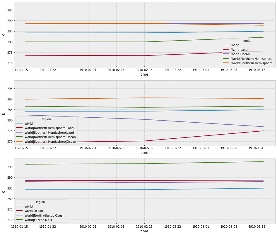
If we have atmosphere data, then we have global coverage and so can split data into both the land and ocean boxes.
[33]:
# NBVAL_IGNORE_OUTPUT
fig = plt.figure(figsize=(16, 14))
ax1 = fig.add_subplot(311)
tas.get_scm_timeseries(
    regions=[
        "World",
        "World|Land",
        "World|Ocean",
        "World|Northern Hemisphere",
        "World|Southern Hemisphere",
    ]
).lineplot(hue="region", ax=ax1)

ax2 = fig.add_subplot(312, sharey=ax1, sharex=ax1)
tas.get_scm_timeseries(
    regions=[
        "World",
        "World|Northern Hemisphere|Land",
        "World|Southern Hemisphere|Land",
        "World|Northern Hemisphere|Ocean",
        "World|Southern Hemisphere|Ocean",
    ]
).lineplot(hue="region", ax=ax2)

ax3 = fig.add_subplot(313, sharey=ax1, sharex=ax1)
tas.get_scm_timeseries(
    regions=[
        "World",
        "World|Ocean",
        "World|North Atlantic Ocean",
        "World|El Nino N3.4",
    ]
).lineplot(hue="region", ax=ax3);
DEBUG:netcdf_scm.iris_cube_wrappers:cell_weights: None
DEBUG:netcdf_scm.iris_cube_wrappers:self.netcdf_scm_realm: atmosphere
DEBUG:netcdf_scm.iris_cube_wrappers:Using: <class 'netcdf_scm.weights.AreaSurfaceFractionWeightCalculator'>
DEBUG:netcdf_scm.iris_cube_wrappers:loading cube ../../../tests/test-data/cmip6output/CMIP6/CMIP/IPSL/IPSL-CM6A-LR/historical/r1i1p1f1/fx/sftlf/gr/v20180803/sftlf_fx_IPSL-CM6A-LR_historical_r1i1p1f1_gr.nc
DEBUG:netcdf_scm.weights:sftlf data max is 100.0, dividing by 100.0 to convert units to fraction
DEBUG:netcdf_scm.iris_cube_wrappers:Crunching SCM timeseries in memory
WARNING:py.warnings:/Users/znicholls/miniconda3/envs/netcdf-scm/lib/python3.9/site-packages/iris/coords.py:1410: UserWarning: Collapsing a non-contiguous coordinate. Metadata may not be fully descriptive for 'latitude'.
  warnings.warn(msg.format(self.name()))

WARNING:py.warnings:/Users/znicholls/miniconda3/envs/netcdf-scm/lib/python3.9/site-packages/iris/coords.py:1410: UserWarning: Collapsing a non-contiguous coordinate. Metadata may not be fully descriptive for 'longitude'.
  warnings.warn(msg.format(self.name()))

WARNING:netcdf_scm.iris_cube_wrappers:Not calculating land fractions as all required cubes are not available
DEBUG:netcdf_scm.iris_cube_wrappers:Crunching SCM timeseries in memory
WARNING:py.warnings:/Users/znicholls/miniconda3/envs/netcdf-scm/lib/python3.9/site-packages/iris/coords.py:1410: UserWarning: Collapsing a non-contiguous coordinate. Metadata may not be fully descriptive for 'latitude'.
  warnings.warn(msg.format(self.name()))

WARNING:py.warnings:/Users/znicholls/miniconda3/envs/netcdf-scm/lib/python3.9/site-packages/iris/coords.py:1410: UserWarning: Collapsing a non-contiguous coordinate. Metadata may not be fully descriptive for 'longitude'.
  warnings.warn(msg.format(self.name()))

WARNING:py.warnings:/Users/znicholls/miniconda3/envs/netcdf-scm/lib/python3.9/site-packages/iris/coords.py:1410: UserWarning: Collapsing a non-contiguous coordinate. Metadata may not be fully descriptive for 'latitude'.
  warnings.warn(msg.format(self.name()))

WARNING:py.warnings:/Users/znicholls/miniconda3/envs/netcdf-scm/lib/python3.9/site-packages/iris/coords.py:1410: UserWarning: Collapsing a non-contiguous coordinate. Metadata may not be fully descriptive for 'longitude'.
  warnings.warn(msg.format(self.name()))

WARNING:py.warnings:/Users/znicholls/miniconda3/envs/netcdf-scm/lib/python3.9/site-packages/iris/coords.py:1410: UserWarning: Collapsing a non-contiguous coordinate. Metadata may not be fully descriptive for 'latitude'.
  warnings.warn(msg.format(self.name()))

WARNING:py.warnings:/Users/znicholls/miniconda3/envs/netcdf-scm/lib/python3.9/site-packages/iris/coords.py:1410: UserWarning: Collapsing a non-contiguous coordinate. Metadata may not be fully descriptive for 'longitude'.
  warnings.warn(msg.format(self.name()))

WARNING:py.warnings:/Users/znicholls/miniconda3/envs/netcdf-scm/lib/python3.9/site-packages/iris/coords.py:1410: UserWarning: Collapsing a non-contiguous coordinate. Metadata may not be fully descriptive for 'latitude'.
  warnings.warn(msg.format(self.name()))

WARNING:py.warnings:/Users/znicholls/miniconda3/envs/netcdf-scm/lib/python3.9/site-packages/iris/coords.py:1410: UserWarning: Collapsing a non-contiguous coordinate. Metadata may not be fully descriptive for 'longitude'.
  warnings.warn(msg.format(self.name()))

WARNING:netcdf_scm.iris_cube_wrappers:Not calculating land fractions as all required cubes are not available
[34]:
# NBVAL_IGNORE_OUTPUT
compare_weighting_options(tas)
WARNING:py.warnings:/Users/znicholls/miniconda3/envs/netcdf-scm/lib/python3.9/site-packages/iris/cube.py:3218: UserWarning: Collapsing spatial coordinate 'latitude' without weighting
  warnings.warn(msg.format(coord.name()))

WARNING:py.warnings:/Users/znicholls/miniconda3/envs/netcdf-scm/lib/python3.9/site-packages/iris/coords.py:1410: UserWarning: Collapsing a non-contiguous coordinate. Metadata may not be fully descriptive for 'latitude'.
  warnings.warn(msg.format(self.name()))

WARNING:py.warnings:/Users/znicholls/miniconda3/envs/netcdf-scm/lib/python3.9/site-packages/iris/coords.py:1410: UserWarning: Collapsing a non-contiguous coordinate. Metadata may not be fully descriptive for 'longitude'.
  warnings.warn(msg.format(self.name()))

WARNING:py.warnings:/Users/znicholls/miniconda3/envs/netcdf-scm/lib/python3.9/site-packages/iris/coords.py:1410: UserWarning: Collapsing a non-contiguous coordinate. Metadata may not be fully descriptive for 'latitude'.
  warnings.warn(msg.format(self.name()))

WARNING:py.warnings:/Users/znicholls/miniconda3/envs/netcdf-scm/lib/python3.9/site-packages/iris/coords.py:1410: UserWarning: Collapsing a non-contiguous coordinate. Metadata may not be fully descriptive for 'longitude'.
  warnings.warn(msg.format(self.name()))

WARNING:py.warnings:/Users/znicholls/miniconda3/envs/netcdf-scm/lib/python3.9/site-packages/iris/coords.py:1410: UserWarning: Collapsing a non-contiguous coordinate. Metadata may not be fully descriptive for 'latitude'.
  warnings.warn(msg.format(self.name()))

WARNING:py.warnings:/Users/znicholls/miniconda3/envs/netcdf-scm/lib/python3.9/site-packages/iris/coords.py:1410: UserWarning: Collapsing a non-contiguous coordinate. Metadata may not be fully descriptive for 'longitude'.
  warnings.warn(msg.format(self.name()))
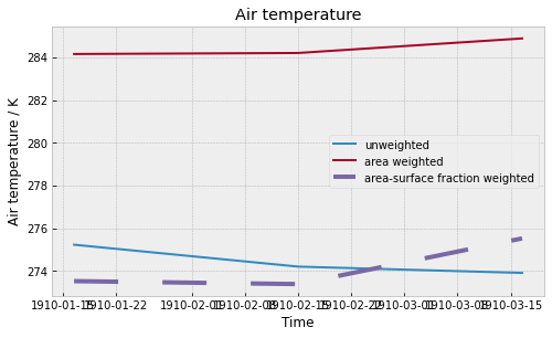
As our data is global, the “World” data is simply an area-weighted mean.
[35]:
# NBVAL_IGNORE_OUTPUT
tas_area = tas.get_metadata_cube(tas.areacell_var).cube

tas_area_weights = broadcast_onto_lat_lon_grid(tas, tas_area.data)
tas_area_weighted_mean = tas.cube.collapsed(
    ["latitude", "longitude"], iris.analysis.MEAN, weights=tas_area_weights
)

netcdf_scm_calculated = tas.get_scm_timeseries(regions=["World"]).timeseries()

np.testing.assert_allclose(
    tas_area_weighted_mean.data, netcdf_scm_calculated.values.squeeze()
)

netcdf_scm_calculated.T
WARNING:py.warnings:/Users/znicholls/miniconda3/envs/netcdf-scm/lib/python3.9/site-packages/iris/coords.py:1410: UserWarning: Collapsing a non-contiguous coordinate. Metadata may not be fully descriptive for 'latitude'.
  warnings.warn(msg.format(self.name()))

WARNING:py.warnings:/Users/znicholls/miniconda3/envs/netcdf-scm/lib/python3.9/site-packages/iris/coords.py:1410: UserWarning: Collapsing a non-contiguous coordinate. Metadata may not be fully descriptive for 'longitude'.
  warnings.warn(msg.format(self.name()))

DEBUG:netcdf_scm.iris_cube_wrappers:Crunching SCM timeseries in memory
WARNING:py.warnings:/Users/znicholls/miniconda3/envs/netcdf-scm/lib/python3.9/site-packages/iris/coords.py:1410: UserWarning: Collapsing a non-contiguous coordinate. Metadata may not be fully descriptive for 'latitude'.
  warnings.warn(msg.format(self.name()))

WARNING:py.warnings:/Users/znicholls/miniconda3/envs/netcdf-scm/lib/python3.9/site-packages/iris/coords.py:1410: UserWarning: Collapsing a non-contiguous coordinate. Metadata may not be fully descriptive for 'longitude'.
  warnings.warn(msg.format(self.name()))

WARNING:netcdf_scm.iris_cube_wrappers:Not calculating land fractions as all required cubes are not available
[35]:
| activity_id | CMIP |
|---|---|
| climate_model | IPSL-CM6A-LR |
| member_id | r1i1p1f1 |
| mip_era | CMIP6 |
| model | unspecified |
| region | World |
| scenario | historical |
| unit | K |
| variable | tas |
| variable_standard_name | air_temperature |
| time | |
| 1910-01-16 12:00:00 | 284.148122 |
| 1910-02-15 00:00:00 | 284.196805 |
| 1910-03-16 12:00:00 | 284.876555 |
The “World|Land” data is surface fraction weighted.
[36]:
# NBVAL_IGNORE_OUTPUT
tas_sf = tas.get_metadata_cube(tas.surface_fraction_var).cube
# netcdf-scm normalises weights to 1 internally so we do so here too
tas_sf = tas_sf / tas_sf.data.max()


tas_area_sf = tas_area * tas_sf

tas_area_sf_weights = broadcast_onto_lat_lon_grid(tas, tas_area_sf.data)
tas_area_sf_weighted_mean = tas.cube.collapsed(
    ["latitude", "longitude"], iris.analysis.MEAN, weights=tas_area_sf_weights
)

netcdf_scm_calculated = tas.get_scm_timeseries(
    regions=["World|Land"]
).timeseries()

np.testing.assert_allclose(
    tas_area_sf_weighted_mean.data, netcdf_scm_calculated.values.squeeze()
)

netcdf_scm_calculated.T
WARNING:py.warnings:/Users/znicholls/miniconda3/envs/netcdf-scm/lib/python3.9/site-packages/iris/coords.py:1410: UserWarning: Collapsing a non-contiguous coordinate. Metadata may not be fully descriptive for 'latitude'.
  warnings.warn(msg.format(self.name()))

WARNING:py.warnings:/Users/znicholls/miniconda3/envs/netcdf-scm/lib/python3.9/site-packages/iris/coords.py:1410: UserWarning: Collapsing a non-contiguous coordinate. Metadata may not be fully descriptive for 'longitude'.
  warnings.warn(msg.format(self.name()))

DEBUG:netcdf_scm.iris_cube_wrappers:Crunching SCM timeseries in memory
WARNING:py.warnings:/Users/znicholls/miniconda3/envs/netcdf-scm/lib/python3.9/site-packages/iris/coords.py:1410: UserWarning: Collapsing a non-contiguous coordinate. Metadata may not be fully descriptive for 'latitude'.
  warnings.warn(msg.format(self.name()))

WARNING:py.warnings:/Users/znicholls/miniconda3/envs/netcdf-scm/lib/python3.9/site-packages/iris/coords.py:1410: UserWarning: Collapsing a non-contiguous coordinate. Metadata may not be fully descriptive for 'longitude'.
  warnings.warn(msg.format(self.name()))

WARNING:netcdf_scm.iris_cube_wrappers:Not calculating land fractions as all required cubes are not available
[36]:
| activity_id | CMIP |
|---|---|
| climate_model | IPSL-CM6A-LR |
| member_id | r1i1p1f1 |
| mip_era | CMIP6 |
| model | unspecified |
| region | World|Land |
| scenario | historical |
| unit | K |
| variable | tas |
| variable_standard_name | air_temperature |
| time | |
| 1910-01-16 12:00:00 | 273.530365 |
| 1910-02-15 00:00:00 | 273.393341 |
| 1910-03-16 12:00:00 | 275.527954 |
The “World|Ocean” data is also surface fraction weighted (calculated as 100 minus land surface fraction).
[37]:
# NBVAL_IGNORE_OUTPUT
tas_sf_ocean = tas.get_metadata_cube(tas.surface_fraction_var).cube
tas_sf_ocean.data = 100 - tas_sf_ocean.data

# netcdf-scm normalises weights to 1 internally so we do so here too
tas_sf_ocean = tas_sf_ocean / tas_sf_ocean.data.max()

tas_area_sf_ocean = tas_area.data * tas_sf_ocean.data

tas_area_sf_ocean_weights = broadcast_onto_lat_lon_grid(tas, tas_area_sf_ocean)
tas_area_sf_ocean_weighted_mean = tas.cube.collapsed(
    ["latitude", "longitude"],
    iris.analysis.MEAN,
    weights=tas_area_sf_ocean_weights,
)

netcdf_scm_calculated = tas.get_scm_timeseries(
    regions=["World|Ocean"]
).timeseries()

np.testing.assert_allclose(
    tas_area_sf_ocean_weighted_mean.data,
    netcdf_scm_calculated.values.squeeze(),
)

netcdf_scm_calculated.T
WARNING:py.warnings:/Users/znicholls/miniconda3/envs/netcdf-scm/lib/python3.9/site-packages/iris/coords.py:1410: UserWarning: Collapsing a non-contiguous coordinate. Metadata may not be fully descriptive for 'latitude'.
  warnings.warn(msg.format(self.name()))

WARNING:py.warnings:/Users/znicholls/miniconda3/envs/netcdf-scm/lib/python3.9/site-packages/iris/coords.py:1410: UserWarning: Collapsing a non-contiguous coordinate. Metadata may not be fully descriptive for 'longitude'.
  warnings.warn(msg.format(self.name()))

DEBUG:netcdf_scm.iris_cube_wrappers:Crunching SCM timeseries in memory
WARNING:py.warnings:/Users/znicholls/miniconda3/envs/netcdf-scm/lib/python3.9/site-packages/iris/coords.py:1410: UserWarning: Collapsing a non-contiguous coordinate. Metadata may not be fully descriptive for 'latitude'.
  warnings.warn(msg.format(self.name()))

WARNING:py.warnings:/Users/znicholls/miniconda3/envs/netcdf-scm/lib/python3.9/site-packages/iris/coords.py:1410: UserWarning: Collapsing a non-contiguous coordinate. Metadata may not be fully descriptive for 'longitude'.
  warnings.warn(msg.format(self.name()))

WARNING:netcdf_scm.iris_cube_wrappers:Not calculating land fractions as all required cubes are not available
[37]:
| activity_id | CMIP |
|---|---|
| climate_model | IPSL-CM6A-LR |
| member_id | r1i1p1f1 |
| mip_era | CMIP6 |
| model | unspecified |
| region | World|Ocean |
| scenario | historical |
| unit | K |
| variable | tas |
| variable_standard_name | air_temperature |
| time | |
| 1910-01-16 12:00:00 | 288.427979 |
| 1910-02-15 00:00:00 | 288.551514 |
| 1910-03-16 12:00:00 | 288.644806 |
For atmosphere data, by default netCDF-SCM will use the area and surface fraction weights. Once again, if we turn the logging up, we can see the decisions being made internally.
[38]:
# NBVAL_IGNORE_OUTPUT
root_logger.setLevel(logging.DEBUG)
tas = CMIP6OutputCube()
tas.load_data_from_path(tas_file)
DEBUG:netcdf_scm.iris_cube_wrappers:loading cube ../../../tests/test-data/cmip6output/CMIP6/CMIP/IPSL/IPSL-CM6A-LR/historical/r1i1p1f1/Amon/tas/gr/v20180803/tas_Amon_IPSL-CM6A-LR_historical_r1i1p1f1_gr_191001-191003.nc
DEBUG:netcdf_scm.iris_cube_wrappers:loading cube ../../../tests/test-data/cmip6output/CMIP6/CMIP/IPSL/IPSL-CM6A-LR/historical/r1i1p1f1/fx/areacella/gr/v20180803/areacella_fx_IPSL-CM6A-LR_historical_r1i1p1f1_gr.nc
[39]:
# NBVAL_IGNORE_OUTPUT
netcdf_scm_calculated = tas.get_scm_timeseries(regions=["World"]).timeseries()

netcdf_scm_calculated.T
DEBUG:netcdf_scm.iris_cube_wrappers:cell_weights: None
DEBUG:netcdf_scm.iris_cube_wrappers:self.netcdf_scm_realm: atmosphere
DEBUG:netcdf_scm.iris_cube_wrappers:Using: <class 'netcdf_scm.weights.AreaSurfaceFractionWeightCalculator'>
DEBUG:netcdf_scm.iris_cube_wrappers:Crunching SCM timeseries in memory
WARNING:py.warnings:/Users/znicholls/miniconda3/envs/netcdf-scm/lib/python3.9/site-packages/iris/coords.py:1410: UserWarning: Collapsing a non-contiguous coordinate. Metadata may not be fully descriptive for 'latitude'.
  warnings.warn(msg.format(self.name()))

WARNING:py.warnings:/Users/znicholls/miniconda3/envs/netcdf-scm/lib/python3.9/site-packages/iris/coords.py:1410: UserWarning: Collapsing a non-contiguous coordinate. Metadata may not be fully descriptive for 'longitude'.
  warnings.warn(msg.format(self.name()))

WARNING:netcdf_scm.iris_cube_wrappers:Not calculating land fractions as all required cubes are not available
[39]:
| activity_id | CMIP |
|---|---|
| climate_model | IPSL-CM6A-LR |
| member_id | r1i1p1f1 |
| mip_era | CMIP6 |
| model | unspecified |
| region | World |
| scenario | historical |
| unit | K |
| variable | tas |
| variable_standard_name | air_temperature |
| time | |
| 1910-01-16 12:00:00 | 284.148122 |
| 1910-02-15 00:00:00 | 284.196805 |
| 1910-03-16 12:00:00 | 284.876555 |